
Walk a Spanaway Street
Begin with one complete address and preserve exactly what the postal and county systems return. The street directory trail moves from geography to names, then from names to documents. It does not prove that every person named is present today. A parcel number is the most useful bridge because it remains stable when a mailing label, street spelling, or house number changes.
- Check the full address with USPS, then keep the returned postal city and ZIP separate from the Spanaway community label.
- Open Pierce County Info By Address or PublicGIS. Select the parcel and copy its parcel number and site address.
- Use ATIP Parcel Search. Record the taxpayer field, mailing address, site address, values, use code, and plat without merging unlike fields.
- Carry the parcel, legal description, and party name into the Auditor index. Follow transfers and other instruments one record at a time.
- Check permits, voter data through its controlled request route, and the Tacoma Suburban directory shelf only when those sources fit the date and question.
This street-by-street order limits false matches. It also gives a fallback when one dynamic portal will not load: retain the parcel or legal description and ask the responsible office for the narrow record.
Spanaway Street Fields in ATIP
The Pierce County Assessor-Treasurer maintains ATIP as the current parcel search. Official GIS metadata documents the fields worth preserving, although the research inspection could not confirm every live control or required marker. The key distinction is between Site_Address, the physical location, and Delivery_Address, the taxpayer mailing address. The taxpayer name is useful evidence, but county metadata warns that it is not always a positive statement of legal ownership.
| Parcel field | Format or role | How it helps by address |
|---|---|---|
| Parcel number | Parcel identifier | Stable key across ATIP, GIS, PALS, plats, and deeds |
| Site address | Physical location | Places the parcel on the Spanaway street |
| Taxpayer name | Metadata result | A search lead, not a title finding |
| Delivery address | Mailing field | Must remain separate from the site address |
| Plat name and number | Recorded geography | Bridges a street address to lot and block records |
| Value, use, exemption | Assessment fields | Describe the tax parcel, not its current occupants |
- Parcel
- A tract tracked by the assessor under a unique number.
- Situs address
- The physical site address, which can differ from the taxpayer's mailing address.
- Plat
- A recorded map that lays out lots, blocks, roads, or a subdivision.
- Criss-cross directory
- A directory arranged by address or phone number rather than only by surname.
An XXX site number means the house number is unverified. Copy that flag instead of turning it into a guessed number.
Map Spanaway Streets in PublicGIS
Pierce County PublicGIS places the parcel in a street and block context. Search by address, select the parcel layer, and click features to inspect their attributes. The Data Menu includes parcels, roads, schools, places of interest, public safety, political boundaries, transportation, utilities, and environmental layers. No one-click radius or ZIP filter was found, so browse adjacent parcels manually. Map lines are approximate, not a survey.
For a street directory, copy the parcel number and site address from each parcel of interest. Do not infer a household from a dot or boundary. The map is strongest as a routing tool: it shows which parcel to take to ATIP, PALS, the recorded plat, or the Auditor. School and public-service layers can also explain why two nearby records use different service areas.
Spanaway's records geography matters here. Pierce County lists Spanaway as an unincorporated community, so county map and planning systems carry the practical local record trail. A Tacoma mailing line on a county facility does not move the parcel into Tacoma city government.
Note: Keep a dated note of every parcel number because map attributes and assessment values can change after a search.
Spanaway Records Indexed by Address
No single roll is a complete Spanaway street directory. The sources below cover different periods and record different relationships to an address. Use the narrowest official source first, then check the underlying document or custodian when the result matters.
| Address source | Record keeper | Street-level evidence | Access route |
|---|---|---|---|
| Assessor parcel | Pierce Assessor-Treasurer | Parcel, taxpayer, site and mailing fields, values, plat | ATIP; Assessor office |
| Parcel map | Pierce County GIS | Adjacent parcels, roads, layers, clicked attributes | PublicGIS and Info By Address |
| Recorded instruments | Pierce County Auditor | Parties, dates, document types, legal descriptions | ARM; Auditor counter and copy request |
| Permits | Planning and Public Works | Work location, status, plans, project parties | PALS; public-record request |
| Voter data | Pierce County Elections | Precinct and district records under use limits | Data request form, not VoteWA reverse search |
| Older directories | State Library and libraries | Printed household or phone entries by address | Onsite and library research resources |
When online access fails, the county supports requests online and by mail, email, fax, or in person. A precise request should state the office, full site address, parcel number, record type, and date span. The county gives an initial response within five business days, though that response can be an estimate, request for clarification, production, or legally grounded denial.
Spanaway Streets Meet Deeds
The Pierce ARM recording system holds the current index and image route. Its public session begins with a disclaimer and date-browse choices. Parcel links may be incomplete, images may be redacted, and the site bars high-volume data mining. Use the parcel, party name, addition, and date window to find a specific instrument, then distinguish the free index from an uncertified or certified copy.
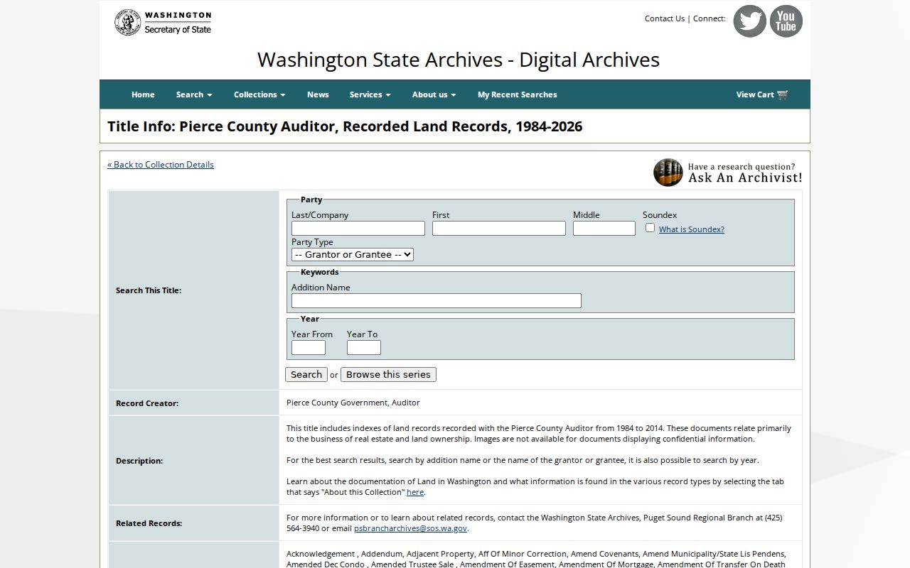
The stable historical field model comes from the Washington Digital Archives Pierce land series. Search fields include Party Last or Company, First, Middle, Soundex, Keywords, Addition Name, and years from and to. The detailed description indexes 8,067,022 records for 1984 through 2014. That range belongs to the archive series, not the full life of Pierce County recording.
The captured Pierce land-record series page shows the route from a Spanaway name or addition into indexed land records.
PALS permit search adds work-location evidence. Address or parcel is the sound starting point. The exact earliest Spanaway coverage was not located, so do not claim that every old permit is online. Plans or records missing from the portal can be requested from Planning and Public Works.
Spanaway's Louvre Street Bridge
Old address strings can hide a valid street directory match. Tacoma Public Library's Buildings Index entry for 102 153RD ST S notes a former Louvre St. So. address and a change around 1986. Search both forms in directories, newspapers, permits, assessor records, and plats. A legal description or parcel number can hold the chain together while the street label changes.
Other Spanaway Buildings Index entries show why address research benefits from local sources. Records along 152ND and 160TH streets include builder, construction, permit-news, fire, and directory clues. These are leads to the cited item, not proof that a named person stayed at the site through every later year. The library's local history and genealogy resources offer the Buildings Index, obituary index, newspapers, photographs, and Northwest Room help.
The broader Tacoma Suburban shelf includes Spanaway in 1974-75 and 1977-84. It is useful for an old by-address search, while the collections themselves belong on the Spanaway city directory page.
Spanaway Streets and Voter Data
VoteWA is not a reverse street directory. Its personal lookup requires first name, last name, date of birth, and CAPTCHA so a voter can reach their own registration. A researcher seeking public election data must instead use the Pierce County Elections request route under RCW 29A.08.720 and accept its political-use conditions.
The county form can request district or precinct files and matchback data. The observed fee is $5 for each district or precinct file and $5 for each requested day of matchbacks. Allow five business days. Street-level election data must stay within the stated purpose and distribution limits, and protected Address Confidentiality Program records are not a source for real locations.
This distinction prevents a common street directory error. A self-service voter portal confirms the signed-in voter's details; it does not invite a casual scan of everyone on a Spanaway block.
Limits of Spanaway Street Records
Address-indexed records show parcels, recorded parties, public permits, and selected historical entries. They do not create a live roster of all people in a home. A taxpayer may not be the vested owner. An owner may live elsewhere. A directory entry can be old, and an index hit is not the certified document behind it. Utility customer and motor-vehicle data are not a lawful shortcut.
Washington's Address Confidentiality Program provides eligible people with a substitute mailing address and mail forwarding. Court records can be sealed, recording images can be restricted or redacted, and voter data has specific limits. Respect those gaps. For a title question, use the recorded instruments and professional title work, not a GIS click or taxpayer field.
Use address records lawfully. Spanaway street records are for legitimate personal, family, property, and civic research. Never use them to stalk, harass, intimidate, or harm anyone.